The "Bomb Cyclone" Is Back And It's Pounding The Northeast
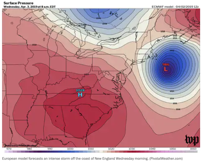
Low-pressure will intensify off the East Coast Wednseday as it tracks northeastward, potentially becoming a bomb cyclone, a term meteorologists use to describe a low-pressure system that drops 24 millibars (or atmospheric pressure) over 24 hours.
The Capital Weather Gang says New York, Boston, and Philadelphia could experience travel disruptions early Wednseday. Low-level wind shear could be a problem at major airports in those regions, possibly causing delays until mid-afternoon.
In the higher elevation regions of Massachusetts, southern New Hampshire, and Vermont, the expectation of snow is high. Regions over 1,000 feet will have a quick "burst of snow," according to the National Weather Service in Boston.
"This is a typical early spring event for us in southern New England," said Bill Simpson, a spokesman at the Weather Service’s Boston office.
Boston will mainly have a rain event on Wednseday morning, but could see snowflakes as the backend of the storm is packed with cold air.
The most severe weather will be seen offshore. Hurricane wind warnings are posted across New England's coast. Sustained winds of 40 to 50 mph, gusting to 75 to 80 mph, will produce rough seas.
Skies will clear across New England in the afternoon as the storm heads for northeast Canada. Temperatures will rise to the lower 50s by late afternoon.
More freak weather and the last bomb cyclone we reported on exploded last month across the Midwest and caused catastrophic floods.


Nenhum comentário:
Postar um comentário