

THE WIRELESS 3-D ELECTRO-MAGNETIC UNIVERSE:The ape body is a reformatory and limited to a 2-strand DNA, 5% brain activation running 22+1 chromosomes and without "eyes". Wireless Scanners feeding the Brain-Mind-Modem-Antenna are wrongly called eyes. Matter/Solids do not exist as 100%...WIRELESS MIND-MODEM- ANTENNA = ARTIFICIAL INTELLIGENCE OF OVER A BILLION YEARS OLD AND WON'T ALLOW HUMANS TO THINK FOR THEMSELVES. IT-AI, ARTIFICIAL INTELLIGENCE OF PLANET EARTH IS LESS THAN 50-YEARS OLD.
MANDALAS, YANTRAS, CHAKRAS, CROP CIRCLES.

THE RAW MAGNETIC FORCE CAN BE ENCODED AND WHEN ENCODED, THE RESULTS ARE MAGNETIC DRIVER-MOTORS WHOSE OPTICAL LAYOUTS APPEAR AS MANDALAS, YANTRAS AND CHAKRAS.
sábado, 30 de setembro de 2017
Ancient Inca Fortress Of Pisaq And Massive Moray Amphitheater In Peru
FROM ANTARTICA TO MACHU PICHU+EL CONDOR PASSA+THE TETRAHEDRON ELECTRO-MAGNETIC SOUND TUNNEL VIA THE FLUTE.
- FIRST AND FOREMOST, TAME YOURSELF
THE ONLY KNOWN POWERFUL COSMIC TUNE OUTSIDE ASIA LEFT BEHIND BY ANCIENT ALIENS AS MEANS OF CONNECTION VIA THE ELECTRO-MAGNETIC TETRAHEDRON SOUND TUNNEL. THE SOUND OF THE UNIVERSE HERE IS THE FLUTE. SEE WHAT HAPPENS WHEN YOU MEDITATE WITH CLOSED EYES AS THE BODY SWITCHES INTO “COMA” MODE AND NAVIGATION ENABLED FOR THE COSMOS ON THE WINGS OF THE POWERFUL CONDOR INSTEAD OF A DRAGON OR A GARUDA.

segunda-feira, 18 de setembro de 2017
September 23 Possibilities – Is This A Great Sign?
THE WIRELESS 3-D ELECTRO-MAGNETIC UNIVERSE: The ape body is a reformatory and limited to a 2-strand DNA, 5% brain activation running 22+1 chromosomes and without "eyes". Wireless Scanners feeding the Brain-Mind-Modem-Antenna are wrongly called eyes. Matter/Solids do not exist as 100%... WIRELESS MIND-MODEM- ANTENNA = ARTIFICIAL INTELLIGENCE OF OVER A BILLION YEARS OLD. IT-AI, ARTIFICIAL INTELLIGENCE OF PLANET EARTH IS LESS THAN 50-YEARS OLD.
domingo, 17 de setembro de 2017
Climate Chaos/Jose/Maria Strengthen.
1. SOLAR FLARES TRIGGERS STEAMING OCEANS.
2. ASTEROID TC4 TRIGGERS HIGHER TIDES.
Something Big is Coming~Hurricane Maria Worst Hurricane On Earth & How To Prepare!?
https://earth.nullschool.net/#current/wind/surface/level/orthographic=-80.96,22.86,1214/loc=-76.435,21.038
sábado, 16 de setembro de 2017
domingo, 10 de setembro de 2017
sábado, 9 de setembro de 2017
terça-feira, 5 de setembro de 2017
On 911 2017 Hurricane IRMA (CAT 5) Predicted To Make A Direct HIT On Mia...
"Monster" Irma Is Now The Strongest Atlantic Hurricane On Record As Florida Preps For "Catastrophe"
========================================
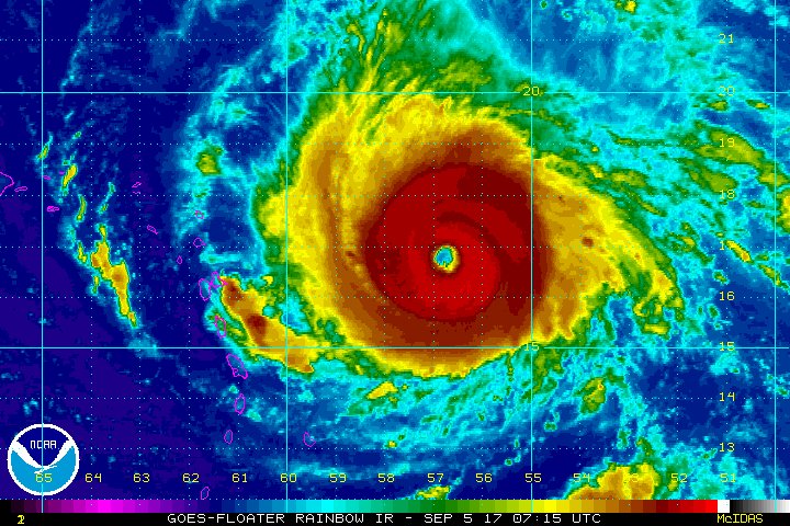
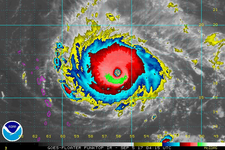
FISH STORM IRMA NOW CONSIDERED TO BE THE MOST POWERFUL HURRICANE EVER @CAT-4. (2017.9.5)
FISH STORM: THIS IS WHAT GOVT. SAID UP TO 2017.8.31.
NHC Atlantic OpsVerified account @NHC_Atlantic Aug 31
More
NHC is monitoring 2 disturbances which both have a low chance (20%) of tropical cyclone formation within 5 days.
http://hurricanes.gov
FLORIDA GOVERNOR THINKS OTHERWISE, DECLARES STATE OF EMERGENCY.
PLANET EARTH SPINNING AGAINST A QUASI-STATIONARY SURFACE BUBBLE OF LOW PRESSURE, LIKE THE PATH THAT TOOK ATLANTIS.
THINGS BEGIN TO STIR UP AROUND THE SEA OF JAPAN THEN THEN CHINA ROTATES INTO IT FOLLOWED BY THE MIDDLE EAST, THE SAHARA WHERE IT ESCALATES BEFORE ATLANTIS-ATLANTIC ROTATES AGAINST THE STATIONARY BUBBLE AND FINALLY THE GULF OF MEXICO BANGS DIRECTLY AGAINST THIS STATIONARY DENSIFIED BUBBLE.
ECLIPSE, FIRE AND FURY PUT ON PAUSE BY THE RAIN FROM THE HEAVENS.
The high elclipse luna tide may be difficult for the overflowing rivers to unload their excess into the ocean.
Fifty inches of rain would exceed any previous Texas rainfall record, the National Weather Service announced Sunday.
"The breadth and intensity of this rainfall are beyond anything experienced before," NWS Weather Prediction Center posted on Twitter. "Catastrophic flooding is now underway and expected to continue for days."
NOTHING UNEXPECTED AND NOTHING UNPREDICTED!. N.KOREA FOLLOW ON ITS ANNOUNCED SCHEDULE OF 10TH AUGUST, BEFORE THE ECLIPSE AND THE ECLIPSED HIGH LUNA TIDE HURRICANE HARVEY OF 24TH AUGUST. HOW DID N KOREA PREDICT THE LANDFALL OF HURRICANE HARVEY AS WELL AS IRMA FOLLOWED BY TWO MORE HURRICANES??
2017.8.10.North Korea details Guam strike plan and calls Trump 'bereft of reason'
Pyongyang says it will launch four missiles into waters ‘30-40km’ off US territory in Pacific Ocean.
August 17, 09:20
• MANSLAUGHTER, FIRE AND FURY CIVIL WAR WITHIN, PACKED AND LOADED WITH NOTHING BURGER PRESIDENT. FROM THE LUNATIC ASYLUM OF WASHINGTON AND NOT NORTH KOREA OR VENEZUELA.
• 1. FIRE AND FURY
• 2. LOCKED AND LOADED
• 3, “We have many options for Venezuela including a possible military option if necessary.”
• 4. DOZENS OF COUNTRIES VIOLATE BASIC HUMAN RIGHTS WILL NOT BE ATTACKED OR SUFFER ECONOMICAL SANCTIONS, SINCE THEY DON'T HAVE THE OIL AND MINERAL RESOURCES OF NORTH KOREA AND VENEZUELA.
• 5. THERE ARE NOW ONLY 3-COUNTRIES STILL FREE FROM THE STRANGLEHOLD OF THE CENTRAL BANKS, IRAN, NORTH KOREA AND CUBA.
https://youtu.be/A6m32JnSBPU
STATE OF EMERGENCY IN LA.Firefighters Gain Ground Against Historic Fire In Los Angeles
The blaze, fueled by triple digit temperatures and erratic winds, has burned 7,000 acres and destroyed four homes.(3.9.2017)
What would happen if 100ft asteroid due to skim just 4,200 miles past Earth in October were to actually hit?
• Asteroid 2012 TC4 will pass 4,200 miles from Earth on October 12, 2017
• If it did hit Earth, researchers say it could cause a great level of impact
• It could be more devastating than the 18-meter asteroid that hit Chelyabinsk
• The 2013 event Russia injured about 1,500 people and damaged 7,000 buildings
• The next close-approach will happen in December 2019 - at 21 million miles awa
Read more: http://www.dailymail.co.uk/sciencetech/article-4779600/What-happen-asteroid-TC4-did-hit-Earth.html#ixzz4rq9M7Cw9
Follow us: @MailOnline on Twitter | DailyMail on Facebook
https://www.youtube.com/watch?v=k5y7nyTTIKk
COMET-SOLAR FALRES IN SEPTEMBER MAY AFFECT EARTH’S MAGNETIC BELT.
https://www.youtube.com/watch?v=gn2Fwi0b0sg
YELLOW STONE SUPER VULCANO. The explosion likely wouldn't wipe out human life, but it certainly would be destructive, especially to the western half of the US.
http://www.businessinsider.com/what-would-happen-if-yellowstone-supervolcano-erupted-2017-6
https://www.youtube.com/watch?v=6AJ5YKnzwHI
Dr Michio Kaku
https://www.youtube.com/watch?v=2waq5gjOnpE
WORLD ECONOMIES STRUGGLING TO ADJOURN COLLAPSE. DEBT OVER US$217-TRILLION AND CLIMBING AT AN ANNUAL RATE OF US$2-TRILLION. MOST OF THE BIGGEST CORPORATIONS AND BANKS ARE BUST, BUT TOO BIG TO FALL WITH SO MUCH OF BAIL OUT MONEY FOR FREE (NEGATIVE INTEREST). NO DEBT RIDDEN COUNTRY WILL GROW OR GENERATE NEW JOBS. KEYNES-IMF-FEDERAL RESERVE ARE TRAPPED INSIDE THEIR OWN PONZI SCHEME OF ZERO VALUE PAPER CURRENCIES AND ATTEMPT TO ENFORCE ADOPTION INFINITELY. TIME IS THEIR ENEMY.
========================================
+++++++++++++++++++++++++++++++++++++++
"Monster" Irma Is Now The Strongest Atlantic Hurricane On Record As Florida Preps For "Catastrophe"
Tyler Durden's picture
by Tyler Durden
Sep 5, 2017 8:28 AM
1.5K
SHARES
TwitterFacebookReddit
Update 3: The Irma hits just keep on coming, with the NHC Atlantic Ops twitter page reporting that as of this moment, Irma is now the stronger hurricane in the Atlantic basin outside of the Caribbean Sea and Gulf of Mexico in NHC records. “Preparations should be rushed to completion in the hurricane warning area,” the NHC said.
Follow
NHC Atlantic Ops ✔ @NHC_Atlantic
#Irma is the strongest #hurricane in the Atlantic basin outside of the Caribbean Sea & Gulf of Mexico in NHC records http://hurricanes.gov
11:51 AM - Sep 5, 2017
265 265 Replies 8,157 8,157 Retweets 4,399 4,399 likes
Twitter Ads info and privacy
Taking things to the next level, literally, meteorologist Eric Holthaus writes that Hurricane Irma is now expected to *exceed* the theoretical maximum intensity for a storm in its environment, or as he puts it "Redefining the rules."
Follow
Eric Holthaus ✔ @EricHolthaus
Wow. Hurricane #Irma is now expected to *exceed* the theoretical maximum intensity for a storm in its environment. Redefining the rules. https://twitter.com/KieranBhatia/status/905152863046955009 …
4:44 PM - Sep 5, 2017
36 36 Replies 842 842 Retweets 495 495 likes
Twitter Ads info and privacy
Puerto Rican Governor Ricardo Rossello urged the 3.4 million residents of the U.S. territory to seek refuge in one of 460 hurricane shelters before the storm is expected to hit as early as Tuesday night. “This is something without precedent,” Rossello told a news conference. He will ask U.S. President Donald Trump to declare a federal state of emergency even before the storm passes to allow disbursement of U.S. emergency funds.
Gary Randall, head of the Blue Waters Resort on Antigua’s north coast, said the staff had boarded up windows, stripped trees of coconuts and fronds and secured anything that could become a hazard. “I wasn’t that nervous yesterday, but today I‘m nervous,” Randall said by telephone, adding that he expected the hotel’s beach to be swept away and much of the 108-room property to be flooded.
According to Bloomberg, Irma’s current path - headed straight for Florida - has prompted the state to prepare for the "catastrophic" system. Unlike Harvey, which caused widespread damage, power outages and flooding and taking almost a fifth of U.S. oil refining capacity offline, Irma is a bigger threat to agriculture, with orange juice futures surging.
Airlines have canceled flights across the Caribbean and are adding planes to evacuate tourists, while cruise-line stocks have tumbled.
Trending Articles
Some "Charitable Humans" Aren't Very Giving Toward "Red…
The social media manager of Charitable Humans didn’t sound particularly giving in a series of despicable tweets…
Powered By
A strike on Florida would be the first time since 1964 that the U.S. was hit by back-to-back storms of Category 3 or more and only the second time since 1851, Henson said. Irma is now among the 7 most powerful storms on record to cross the Atlantic.
“Our biggest concern is Florida citrus,” said Joel Widenor, co-founder of Commodity Weather Group LLC in Bethesda, Maryland. “There is big enough fruit on the trees that the fruit could drop off, it could literally get blown off. The bigger issue is tree damage that is a lot harder to recover from.”
Some more facts: Florida is the world’s largest producer of orange juice after Brazil. About two-thirds of the state’s citrus crop is located in the lower two-thirds of the peninsula. Orange juice for November delivery jumped as much as 6.9 percent to $1.4595 a pound on ICE Futures U.S. Tuesday, the biggest intraday gain for the contract since Jan. 28, 2016. Cotton for December delivery jumped by the 3-cent exchange limit, or 4.2 percent, to 74.88 cents a pound. Aggregate trading for both commodities for this time doubled compared with the 100-day average, according to data compiled by Bloomberg.
“There is an increasing chance of seeing some impacts from Irma in the Florida Peninsula and the Florida Keys later this week,” the National Hurricane Center said after Governor Rick Scott declared an emergency.
There is still hope that a direct hit will be avoided: "The expected path has shifted considerably west over the last two days and can still change over the next two," said Olivier Jakob, founder of energy consultant Petromatrix GmbH in Zug, Switzerland. “We cannot yet rule out a move further west with a Louisiana risk.”
Irma’s track could shift as it nears Cuba and Florida, according to Bob Henson, a meteorologist with Weather Underground in Boulder, Colorado. One possibility is a turn to the north that would take the storm up the Florida peninsula.
“It is four to five days away,” Henson said. “In hurricane-land that is a pretty long time span.”
Beyond the threat to people and property in the Caribbean, the focus for now is on agriculture, Jakob said. Irma is leading traders to be “long orange Juice futures rather than gasoline futures," he said.
Only three Category 5 hurricanes have hit the contiguous 48 U.S. states, Henson told Bloomberg. The Labor Day Hurricane of 1935 that devastated the Florida Keys, Hurricane Camille in 1969 and Hurricane Andrew that cut across Florida in 1992. Andrew was originally classified as a Category 4 storm only to be upgraded years later after further analysis.
“It is obviously a rare breed,” Henson said. “We are in rare territory.”
* * *
Update 2: While few are willing to admit it yet, according to meteorologist Ryan Maye, Hurricane Irma is still intensifying, with winds up to 155-knots (180 mph) and that extrapolating Saffir-Simpson scale, 158-knots would be Category 6.
View image on TwitterView image on Twitter
Follow
Ryan Maue ✔ @RyanMaue
Hurricane #Irma is still intensifying. Now up to 155-knots (180 mph)
Extrapolating Saffir-Simpson scale, 158-knots would be Category 6.
11:56 AM - Sep 5, 2017
38 38 Replies 573 573 Retweets 386 386 likes
Twitter Ads info and privacy
* * *
Update: Irma has been upgraded from a Cat 5+ Hurricane to "Potentially Catastrophic" Cat 5++ storm, with winds now near 180 mph gusting to 220 mph, still moving due west at 14 mph.
Follow
Antigua Met Service @anumetservice
#Irma has gone from Cat 5+ to Cat 5++, winds are now near 180 mph gusting to 220 mph, mvng due west at 14 mphhttp://www.nhc.noaa.gov/text/refresh/MIATCPAT1+shtml/051159.shtml …?
11:59 AM - Sep 5, 2017
12 12 Replies 289 289 Retweets 90 90 likes
Twitter Ads info and privacy
Here is the latest NHC update:
At 1100 AM AST (1500 UTC), the eye of Hurricane Irma was located near latitude 16.8 North, longitude 58.4 West. Irma is moving toward the west near 14 mph (22 km/h), and this general motion is expected to continue today, followed by a turn toward the west-northwest tonight. On the forecast track, the extremely dangerous core of Irma is forecast to move over portions of the northern Leeward Islands tonight and early Wednesday.
Reports from an Air Force Hurricane Hunter aircraft indicate that the maximum sustained winds are near 180 mph (285 km/h) with higher gusts. Irma is a an extremely dangerous category 5 hurricane on the Saffir-Simpson Hurricane Wind Scale. Some fluctuations in intensity are likely during the next day or two, but Irma is forecast to remain a powerful category 4 or 5 hurricane during the next couple of days.
Hurricane-force winds extend outward up to 60 miles (95 km) from the center and tropical-storm-force winds extend outward up to 160 miles (260 km).
The latest minimum central pressure reported by reconnaissance aircraft is 931 mb (27.50 inches).
* * *
Irma has strengthened to an "extremely dangerous" Category 5 hurricane, the National Hurricane Center said in its advisory at 7:45am AST. According to the Hurricane center, NOAA and Air Force hurricane hunter aircraft data indicate Hurricane Irma has intensified into an "extremely dangerous" Category 5 hurricane on the Saffir-Simpson Hurricane Wind Scale with maximum winds of 175 mph (280 km/h) with higher gusts.
View image on TwitterView image on Twitter
Follow
Eric Webb @webberweather
Recon finds surface winds of 152 knots (175 mph) in #Irma's right front quadrant. Holy crap.
8:34 AM - Sep 5, 2017
4 4 Replies 75 75 Retweets 70 70 likes
Twitter Ads info and privacy
As of this moment, the hurricane is located 270 miles east of Antigua, moving west at 14 mph. States of emergency were declared in Puerto Rico, the U.S. Virgin Islands and all of Florida while people on various Caribbean islands boarded up homes and rushed to find last-minute supplies, forming long lines outside supermarkets and gas stations. This morning the Dominican Republic has issued a Hurricane Watch from Cabo Engano to northern border with Haiti; Tropical Storm Watch from south of Cabo Engao to Isla Saona.
View image on Twitter
View image on Twitter
Follow
HurricaneTracker App @hurrtrackerapp
BREAKING: Hurricane #Irma is the first Category 5 storm of the 2017 Atlantic season. Winds are at 175 mph. This is a very dangerous storm!
8:47 AM - Sep 5, 2017
14 14 Replies 715 715 Retweets 325 325 likes
Twitter Ads info and privacy
According to meteorologists, Irma is the 17th hurricane in the Atlantic on record to have max winds >= 175 mph. Atlantic max wind record is Allen (1980) at 190 mph.
Follow
Philip Klotzbach ✔ @philklotzbach
#Irma is the 17th hurricane in the Atlantic on record to have max winds >= 175 mph. Atlantic max wind record is Allen (1980) at 190 mph.
9:18 AM - Sep 5, 2017
28 28 Replies 643 643 Retweets 588 588 likes
Twitter Ads info and privacy
Ultimately, the question is how strong Irma will be when it inevitably makes landfall on the Eastern Seaboard, somewhere in the vicinity of Miami.
Meanwhile, officials across the northeastern Caribbean canceled airline flights, shuttered schools and urged people to hunker down indoors as Hurricane Irma barreled toward the region, now as an "extremely powerful" Category 5 storm. Irma's maximum sustained winds increased to near 175 mph early Tuesday.
According to AP, emergency officials warned that the storm could dump up to 10 inches (25 centimeters) of rain, unleash landslides and dangerous flash floods and generate waves of up to 23 feet (7 meters) as the storm drew closer.
"We're looking at Irma as a very significant event," Ronald Jackson, executive director of the Caribbean Disaster Emergency Management Agency, said by phone. "I can't recall a tropical cone developing that rapidly into a major hurricane prior to arriving in the central Caribbean."
U.S. residents were urged to monitor the storm's progress in case it should turn northward toward Florida, Georgia or the Carolinas. "This hurricane has the potential to be a major event for the East Coast. It also has the potential to significantly strain FEMA and other governmental resources occurring so quickly on the heels of (Hurricane) Harvey," Evan Myers, chief operating officer of AccuWeather, said in a statement.
In the Caribbean, the director of Puerto Rico's power company predicted that storm damage could leave some areas of the U.S. territory without electricity for four to six months. But "some areas will have power (back) in less than a week," Ricardo Ramos told radio station Notiuno 630 AM.
The power company's system has deteriorated greatly amid Puerto Rico's decade-long recession, and the territory experienced an islandwide outage last year. Meanwhile, the governor of the British Virgin Islands urged people on Anegada island to leave if they could, noting that Irma's eye was expected to pass 35 miles (56 kilometers) from the capital of Road Town.
"This is not an opportunity to go outside and try to have fun with a hurricane," U.S. Virgin Islands Gov. Kenneth Mapp warned. "It's not time to get on a surfboard."
Antigua and Anguilla shuttered schools Monday, and government office closures were expected to follow. On the tiny island of Barbuda, hotel manager Andrea Christian closed the Palm Tree Guest House. She said she was not afraid even though it would be her first time facing a storm of that magnitude.
"We can't do anything about it," Christian said by phone, adding that she had stocked up on food and water. "We just have to wait it out."
Both Puerto Rico and the U.S. Virgin Islands expected 4 inches to 8 inches (10-20 centimeters) of rain and winds of 40-50 mph with gusts of up to 60 mph. Puerto Rico Gov. Ricardo Rossello activated the National Guard, canceled classes for Tuesday and declared a half-day of work. He also warned of flooding and power outages. "It's no secret that the infrastructure of the Puerto Rico Power Authority is deteriorated," Rossello said.
Meteorologist Roberto Garcia warned that Puerto Rico could experience hurricane-like conditions in the next 48 hours should the storm's path shift. "Any deviation, which is still possible, could bring even more severe conditions to Puerto Rico and the U.S. Virgin Islands," Garcia said. The U.S. Virgin Islands said the school year would open Friday instead of Tuesday.
Gov. Kenneth Mapp said most hotels in the U.S. territory were at capacity with some 5,000 tourists. He noted the storm was expected to pass 40 miles (64 kilometers) north of St. Thomas and warned that the island could experience sustained winds as high as 80 mph
"It's not a lot of distance," he said, adding: "It could affect us in a tremendous way. I'm not saying that to alarm anyone or scare anyone, but I want the Virgin Islands to be prepared."
Residents on the U.S. East Coast were urged to monitor the storm's progress due to the possibility it could turn northward toward Florida, Georgia or the Carolinas. "This hurricane has the potential to be a major event for the East Coast. It also has the potential to significantly strain FEMA and other governmental resources occurring so quickly on the heels of (Hurricane) Harvey," Evan Myers, chief operating officer of AccuWeather, said in a statement.
Follow
Rick Scott ✔ @FLGovScott
Just spoke to @POTUS - he offered the full resources of the federal government as Floridians prepare for Hurricane Irma.
11:50 PM - Sep 4, 2017
352 352 Replies 2,594 2,594 Retweets 5,076 5,076 likes
Twitter Ads info and privacy
In Miami-Dade County, the early scramble was on to stock up on hurricane supplies, reports CBS Miami. People were shopping for gasoline, generators, food, batteries, and everything else they'd need get by were Irma to hit the region hard.
"We are not yet at the height of hurricane season and people have not taken steps to get prepared yet," Miami-Dade County Emergency Management Director Curt Sommerhoff said Monday. "We are encouraging them to take those steps today." Miami-Dade officials were to meet Tuesday to assess the danger.
N.O.A.A. FLIES PLANE THROUGH IRMA, FLORIDA GOV TO DECLARE STATE OF EMERG...
"Monster" Irma Is Now The Strongest Atlantic Hurricane On Record As Florida Preps For "Catastrophe"
===============================
FISH STORM IRMA NOW CONSIDERED TO BE THE MOST POWERFUL HURRICANE EVER @CAT-4. (2017.9.5) |
FISH STORM: THIS IS WHAT GOVT. UP NHC Atlantic OpsVerified account @NHC_Atlantic Aug 31 More NHC is monitoring 2 disturbances which both have a low chance (20%) of tropical cyclone formation within 5 days. FLORIDA GOVERNOR THINKS OTHERWISE, DECLARES STATE OF EMERGENCY. |
PLANET EARTH SPINNING AGAINST A QUASI-STATIONARY SURFACE BUBBLE OF LOW PRESSURE, LIKE THE PATH THAT TOOK ATLANTIS. THINGS BEGIN TO STIR UP AROUND THE SEA OF JAPAN THEN THEN CHINA ROTATES INTO IT FOLLOWED BY THE MIDDLE EAST, THE SAHARA WHERE IT ESCALATES BEFORE ATLANTIS-ATLANTIC ROTATES AGAINST THE STATIONARY BUBBLE AND FINALLY THE GULF OF MEXICO BANGS DIRECTLY AGAINST THIS STATIONARY DENSIFIED BUBBLE. ECLIPSE, FIRE AND FURY PUT ON PAUSE BY THE RAIN FROM THE HEAVENS. The high into the ocean. Fifty inches of rain would exceed any previous Texas rainfall record, the National Weather Service announced Sunday. "The breadth and intensity of this rainfall are beyond anything experienced before," NWS Weather Prediction Center posted on Twitter. "Catastrophic flooding is now underway and expected to continue for days." |
NOTHING UNEXPECTED AND NOTHING UNPREDICTED!. N.KOREA FOLLOW ON ITS ANNOUNCED SCHEDULE OF 10TH AUGUST, BEFORE THE ECLIPSE AND THE ECLIPSED HIGH LUNA TIDE HURRICANE HARVEY OF 24TH AUGUST. HOW DID N KOREA PREDICT THE LANDFALL OF HURRICANE HARVEY AS WELL AS IRMA FOLLOWED BY TWO MORE HURRICANES?? 2017.8.10.North Korea details Guam strike Pyongyang says it will launch four missiles into waters ‘30-40km’ off US territory in |
August 17, 09:20 · MANSLAUGHTER, FIRE AND FURY CIVIL WAR WITHIN, PACKED AND LOADED WITH NOTHING BURGER PRESIDENT. FROM THE LUNATIC ASYLUM OF WASHINGTON AND NOT NORTH KOREA OR VENEZUELA. · 1. FIRE AND FURY · 2. LOCKED AND LOADED · 3, “We have many options for Venezuela including a possible military option if necessary.” · 4. DOZENS OF COUNTRIES VIOLATE BASIC HUMAN RIGHTS WILL NOT BE ATTACKED OR SUFFER ECONOMICAL SANCTIONS, SINCE THEY DON'T HAVE THE OIL AND MINERAL RESOURCES OF NORTH KOREA AND VENEZUELA. · 5. THERE ARE NOW ONLY 3-COUNTRIES STILL FREE FROM THE STRANGLEHOLD OF THE CENTRAL BANKS, IRAN, NORTH KOREA AND CUBA. |
STATE OF EMERGENCY IN LA Historic Fire In Los Angeles The blaze, fueled by triple digit temperatures and erratic winds, has burned 7,000 acres and destroyed four homes |
What would happen if 100ft asteroid due to skim just 4,200 miles past Earth in October were to actually hit? · Asteroid 2012 TC4 will pass 4,200 miles from Earth on October 12, 2017 · If it did hit Earth, researchers say it could cause a great level of impact · It could be more devastating than the 18-meter asteroid that hit Chelyabinsk · The 2013 event Russia injured about 1,500 people and damaged 7,000 buildings · The next close-approach will happen in December 2019 - at 21 million miles Read more: http://www.dailymail.co.uk/sciencetech/article-4779600/What-happen-asteroid-TC4-did-hit-Earth.html#ixzz4rq9M7Cw9 Follow us: @MailOnline on Twitter | on Facebook |
COMET-SOLAR FALRES IN SEPTEMBER MAY AFFECT EARTH’S MAGNETIC BELT. |
YELLOW STONE SUPER VULCANO. The explosion likely wouldn't wipe out human life, but it certainly would be destructive, especially Dr Michio Kaku |
WORLD ECONOMIES STRUGGLING TO ADJOURN COLLAPSE. DEBT OVER US$217-TRILLION AND CLIMBING AT AN ANNUAL RATE OF US$2-TRILLION. MOST OF THE BIGGEST CORPORATIONS AND BANKS ARE BUST, BUT TOO BIG TO FALL WITH SO MUCH OF BAIL OUT MONEY FOR FREE (NEGATIVE INTEREST). NO DEBT RIDDEN COUNTRY WILL GROW OR GENERATE NEW JOBS. KEYNES-IMF-FEDERAL RESERVE ARE TRAPPED INSIDE THEIR OWN PONZI SCHEME OF ZERO VALUE PAPER CURRENCIES AND ATTEMPT TO ENFORCE ADOPTION INFINITELY. TIME IS THEIR ENEMY. |
===============================
Update 3: The Irma hits just keep on coming, with the NHC Atlantic Ops twitter page reporting that as of this moment, Irma is now the stronger hurricane in the Atlantic basin outside of the Caribbean Sea and Gulf of Mexico in NHC records. “Preparations should be rushed to completion in the hurricane warning area,” the NHC said.
#Irma is the strongest #hurricane in the Atlantic basin outside of the Caribbean Sea & Gulf of Mexico in NHC records hurricanes.gov
Taking things to the next level, literally, meteorologist Eric Holthaus writes that Hurricane Irma is now expected to *exceed* the theoretical maximum intensity for a storm in its environment, or as he puts it "Redefining the rules."
Wow. Hurricane #Irma is now expected to *exceed* the theoretical maximum intensityfor a storm in its environment. Redefining the rules. twitter.com/KieranBhatia/s…
Puerto Rican Governor Ricardo Rossello urged the 3.4 million residents of the U.S. territory to seek refuge in one of 460 hurricane shelters before the storm is expected to hit as early as Tuesday night. “This is something without precedent,” Rossello told a news conference. He will ask U.S. President Donald Trump to declare a federal state of emergency even before the storm passes to allow disbursement of U.S. emergency funds.
Gary Randall, head of the Blue Waters Resort on Antigua’s north coast, said the staff had boarded up windows, stripped trees of coconuts and fronds and secured anything that could become a hazard. “I wasn’t that nervous yesterday, but today I‘m nervous,” Randall said by telephone, adding that he expected the hotel’s beach to be swept away and much of the 108-room property to be flooded.
According to Bloomberg, Irma’s current path - headed straight for Florida - has prompted the state to prepare for the "catastrophic" system. Unlike Harvey, which caused widespread damage, power outages and flooding and taking almost a fifth of U.S. oil refining capacity offline, Irma is a bigger threat to agriculture, with orange juice futures surging.

Airlines have canceled flights across the Caribbean and are adding planes to evacuate tourists, while cruise-line stocks have tumbled.
Trending Articles

A strike on Florida would be the first time since 1964 that the U.S.was hit by back-to-back storms of Category 3 or more and only the second time since 1851, Henson said. Irma is now among the 7 most powerful storms on record to cross the Atlantic.“Our biggest concern is Florida citrus,” said Joel Widenor, co-founder ofCommodity Weather Group LLC in Bethesda, Maryland. “There is big enough fruit on the trees that the fruit could drop off, it could literally get blown off. The bigger issue is tree damage that is a lot harder to recover from.”
Some more facts: Florida is the world’s largest producer of orange juice after Brazil. About two-thirds of the state’s citrus crop is located in the lower two-thirds of the peninsula. Orange juice for November delivery jumped as much as 6.9 percent to $1.4595 a pound on ICE Futures U.S. Tuesday, the biggest intraday gain for the contract since Jan. 28, 2016. Cotton for December delivery jumped by the 3-cent exchange limit, or 4.2 percent, to 74.88 cents a pound. Aggregate trading for both commodities for this time doubled compared with the 100-day average, according to data compiled by Bloomberg.
“There is an increasing chance of seeing some impacts from Irma in the Florida Peninsula and the Florida Keys later this week,” the National Hurricane Center said after Governor Rick Scott declared an emergency.
There is still hope that a direct hit will be avoided: "The expected path has shifted considerably west over the last two days and can still change over the next two," said Olivier Jakob, founder of energy consultant Petromatrix GmbH in Zug, Switzerland. “We cannot yet rule out a move further west with a Louisiana risk.”
Irma’s track could shift as it nears Cuba and Florida, according to Bob Henson, a meteorologist withWeather Underground in Boulder, Colorado. One possibility is a turn to the north that would take the storm up the Florida peninsula.“It is four to five days away,” Henson said. “In hurricane-land that is a pretty long time span.”
Beyond the threat to people and property in the Caribbean, the focus for now is on agriculture, Jakob said. Irma is leading traders to be “long orange Juice futures rather than gasoline futures," he said.
Only three Category 5 hurricanes have hit the contiguous 48 U.S. states , Henson told Bloomberg. The Labor Day Hurricane of 1935 that devastated the Florida Keys, Hurricane Camille in 1969 and Hurricane Andrew that cut across Florida in 1992. Andrew was originally classified as a Category 4 storm only to be upgraded years later after further analysis.
“It is obviously a rare breed,” Henson said. “We are in rare territory.”
* * *
Update 2: While few are willing to admit it yet, according to meteorologist Ryan Maye, Hurricane Irma is still intensifying, with winds up to 155-knots (180 mph) and that extrapolating Saffir-Simpson scale, 158-knots would be Category 6.


* * *
Update: Irma has been upgraded from a Cat 5+ Hurricane to "Potentially Catastrophic" Cat 5++ storm, with winds now near 180 mph gusting to 220 mph, still moving due west at 14 mph.

#Irma has gone from Cat 5+ to Cat 5++,winds are now near 180 mph gusting to 220 mph,mvng due west at 14mph nhc.noaa.gov/text/refresh/M…?
Here is the latest NHC update:
At 1100 AM AST (1500 UTC), the eye of Hurricane Irma was located near latitude 16.8 North, longitude 58.4 West. Irma is moving toward the west near 14 mph (22 km/h), and this general motion is expected to continue today, followed by a turn toward the west-northwest tonight. On the forecast track, the extremely dangerous core of Irma is forecast to move over portions of the northern Leeward Islands tonight and early Wednesday.Reports from an Air Force Hurricane Hunter aircraft indicate that the maximum sustained winds are near 180 mph (285 km/h) with higher gusts. Irma is a an extremely dangerous category 5 hurricane on the Saffir-Simpson Hurricane Wind Scale. Some fluctuations in intensity are likely during the next day or two, but Irma is forecast to remain a powerful category 4 or 5 hurricane during the next couple of days.Hurricane-force winds extend outward up to 60 miles (95 km) from the center and tropical-storm-force winds extend outward up to 160 miles (260 km).The latest minimum central pressure reported by reconnaissance aircraft is 931mb (27.50 inches).
* * *
Irma has strengthened to an "extremely dangerous" Category 5 hurricane, the National Hurricane Center said in its advisory at 7:45am AST. According to the Hurricane center, NOAA and Air Force hurricane hunter aircraft data indicate Hurricane Irma has intensified into an "extremely dangerous" Category 5 hurricane on the Saffir-Simpson Hurricane Wind Scale with maximum winds of 175 mph (280 km/h) with higher gusts.


As of this moment, the hurricane is located 270 miles east of Antigua, moving west at 14 mph. States of emergency were declared in Puerto Rico, the U.S. Virgin Islands and all of Florida while people on various Caribbean islands boarded up homes and rushed to find last-minute supplies, forming long lines outside supermarkets and gas stations. This morning the Dominican Republic has issued a Hurricane Watch from Cabo Engano to northern border with Haiti; Tropical Storm Watch from south of Cabo Engao to Isla Saona.

According to meteorologists, Irma is the 17th hurricane in the Atlantic on record to have max winds >= 175 mph. Atlantic max wind record is Allen (1980) at 190 mph.
Ultimately, the question is how strong Irma will be when it inevitably makes landfall on the Eastern Seaboard, somewhere in the vicinity of Miami.

Meanwhile, officials across the northeastern Caribbean canceled airline flights, shuttered schools and urged people to hunker down indoors as Hurricane Irma barreled toward the region, now as an "extremely powerful" Category 5 storm. Irma's maximum sustained winds increased to near 175 mph early Tuesday.
According to AP, emergency officials warned that the storm could dump up to 10 inches (25 centimeters) of rain, unleash landslides and dangerous flash floods and generate waves of up to 23 feet (7 meters) as the storm drew closer.
"We're looking at Irma as a very significant event," Ronald Jackson, executive director of the Caribbean Disaster Emergency Management Agency, said by phone. "I can't recall a tropical cone developing that rapidly into a major hurricane prior to arriving in the central Caribbean."
U.S. residents were urged to monitor the storm's progress in case it should turn northward toward Florida, Georgia or the Carolinas. "This hurricane has the potential to be a major event for the East Coast. It also has the potential to significantly strain FEMA and other governmental resources occurring so quickly on the heels of (Hurricane) Harvey," Evan Myers, chief operating officer of AccuWeather, said in a statement.
In the Caribbean, the director of Puerto Rico's power company predicted that storm damage could leave some areas of the U.S. territory without electricity for four to six months. But "some areas will have power (back) in less than a week," Ricardo Ramos told radio station Notiuno 630 AM.
The power company's system has deteriorated greatly amid Puerto Rico's decade-long recession, and the territory experienced an islandwide outage last year. Meanwhile, the governor of the British Virgin Islands urged people on Anegada island to leave if they could, noting that Irma's eye was expected to pass 35 miles (56 kilometers) from the capital of Road Town.
"This is not an opportunity to go outside and try to have fun with a hurricane," U.S. Virgin Islands Gov. Kenneth Mapp warned. "It's not time to get on a surfboard."
Antigua and Anguilla shuttered schools Monday, and government office closures were expected to follow. On the tiny island of Barbuda, hotel manager Andrea Christian closed the Palm Tree Guest House. She said she was not afraid even though it would be her first time facing a storm of that magnitude.
"We can't do anything about it," Christian said by phone, adding that she had stocked up on food and water. "We just have to wait it out."
Both Puerto Rico and the U.S. Virgin Islands expected 4 inches to 8 inches (10-20 centimeters) of rain and winds of 40-50 mph with gusts of up to 60 mph. Puerto Rico Gov. Ricardo Rossello activated the National Guard, canceled classes for Tuesday and declared a half-day of work. He also warned of flooding and power outages. "It's no secret that the infrastructure of the Puerto Rico Power Authority is deteriorated ," Rossello said.
Meteorologist Roberto Garcia warned that Puerto Rico could experience hurricane-like conditions in the next 48 hours should the storm's path shift. "Any deviation, which is still possible, could bring even more severe conditions to Puerto Rico and the U.S. Virgin Islands," Garcia said. The U.S. Virgin Islands said the school year would open Friday instead of Tuesday.
Gov. Kenneth Mapp said most hotels in the U.S. territory were at capacity with some 5,000 tourists. He noted the storm was expected to pass 40 miles (64 kilometers) north of St. Thomas and warned that the island could experience sustained winds as high as 80 mph
"It's not a lot of distance," he said, adding: "It could affect us in a tremendous way. I'm not saying that to alarm anyone or scare anyone, but I want the Virgin Islands to be prepared."
Residents on the U.S. East Coast were urged to monitor the storm's progress due to the possibility it could turn northward toward Florida, Georgia or the Carolinas. "This hurricane has the potential to be a major event for the East Coast. It also has the potential to significantly strain FEMA and other governmental resources occurring so quickly on the heels of (Hurricane) Harvey," Evan Myers, chief operating officer of AccuWeather, said in a statement.
In Miami-Dade County, the early scramble was on to stock up on hurricane supplies, reports CBS Miami. People were shopping for gasoline, generators, food, batteries, and everything else they'd need get by were Irma to hit the region hard.
"We are not yet at the height of hurricane season and people have not taken steps to get prepared yet," Miami-Dade County Emergency Management Director Curt Sommerhoff said Monday. "We are encouraging them to take those steps today." Miami-Dade officials were to meet Tuesday to assess the danger.
Assinar:
Postagens (Atom)